 |

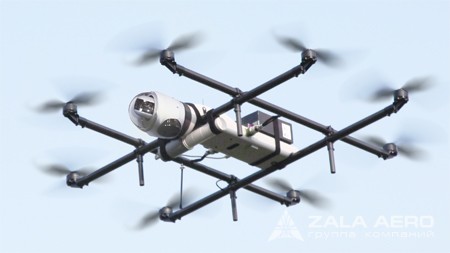
UAV ZALA 421-22F
Specialized line ZALA GEO complemented by a new drone - ZALA 421-22F.
Part number:
Supplier:
Group of companies ZALA AERODescription
Radius radio 5 km / 5 km
The flight duration of 35 minutes
Maximum altitude 1000 m
Running Vertical - automatic
Landing Vertical - automatic
Engine Type Electric drawing - vosmirotornaya scheme (in emergency situation in case of failure of one engine will continue flight)
The speed of 30 km / h
Maximum take-off weight of 8 kg
Mass target load 2 kg
Navigation GPS / GLONASS
Target loads Type 16E +
Glider Demountable - interchangeable frame (foldable) and fuselage
Battery 10,000 mAh 7S x2 (in emergency situation will continue to fly on one battery)
Temperature range -30 ° C ... + 40 ° C
ZALA 421-22F represents drone vertical takeoff / landing constructed from vosmirotornoy scheme. The device does not require a specially prepared runway, it can be used even in the most difficult terrain. To obtain high-quality images from a height of 1,000 meters and at a distance of 5 km UAV is equipped with universal target loads like "16E +» - the Z-16F1 / Bk , the Z-16F2 / Bk , the Z-16F3 / Bk , the Z-16 AGRO 4 and Z-16 AGRO 6 . The apparatus can shoot in both automatic and semi-automatic modes.
Also for UAV ZALA 421-22F given its technical capacity has been specially designed a new target load Z-22F1 / RN on a gyro-stabilized electromagnetic suspension that allows to simultaneously obtain pictures as well as real-time monitor the flight of the UAV.
It should be noted that the Z-22F1 / RN is unique in its class: it is designed for the most detailed examination of objects even from a height of 200 meters, at the same time, the resulting images are of the highest quality. Through enhanced stabilization of the electromagnetic suspension of the target load maximally reduced influence of external factors on the quality of the obtained photographs.
UAV ZALA and above target loads to date the most effective and economically advantageous solution tasks in surveying and mapping, as the image obtained with the UAV after processing in specialized software provides the foundation for digital maps, topographical fotoplanov and three-dimensional terrain models.
Additionally, UAV ZALA 421-22F may be provided with target loadings Z-16AGRO 4 and Z-16AGRO 6 , designed for the monitoring of agricultural land. TSN allows getting images for the most accurate analysis and evaluation of vegetation, as well as the calculation of the normalized vegetation index the NDVI, which allows a short time to solve the most complex problems of agriculture.